


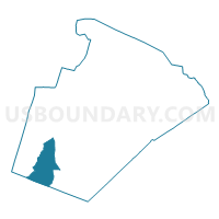
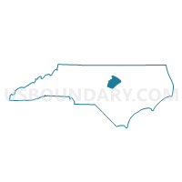
Voting District 06-01, Wake County, North Carolina
About
Outline

Summary
| Unique Area Identifier | 641749 |
| Name | Voting District 06-01 |
| County | Wake County |
| State | North Carolina |
| Area (square miles) | 33.16 |
| Land Area (square miles) | 32.38 |
| Water Area (square miles) | 0.78 |
| % of Land Area | 97.66 |
| % of Water Area | 2.34 |
| Latitude of the Internal Point | 35.63147150 |
| Longtitude of the Internal Point | -78.87318420 |
Maps

Graphs
Select a template below for downloading or customizing gragh for Voting District 06-01, Wake County, North Carolina


Neighbors
Neighoring Voting District (by Name) Neighboring Voting District on the Map
- Voting District 03-00, Wake County, NC
- Voting District 06-04, Wake County, NC
- Voting District 06-06, Wake County, NC
- Voting District 12-08, Wake County, NC
- Voting District 12-09, Wake County, NC
- Voting District 20, Chatham County, NC
- Voting District 20-01, Wake County, NC
- Voting District 20-06, Wake County, NC
- Voting District PR28, Harnett County, NC
Top 10 Neighboring County Subdivision (by Population) Neighboring County Subdivision on the Map
- White Oak township, Wake County, NC (72,894)
- Middle Creek township, Wake County, NC (44,136)
- Holly Springs township, Wake County, NC (33,071)
- Buckhorn township, Wake County, NC (3,251)
- Buckhorn township, Harnett County, NC (2,435)
- Cape Fear township, Chatham County, NC (1,323)
Top 10 Neighboring Place (by Population) Neighboring Place on the Map
Top 10 Neighboring Unified School District (by Population) Neighboring Unified School District on the Map
- Wake County Schools, NC (900,993)
- Harnett County Schools, NC (114,678)
- Chatham County Schools, NC (63,505)
Top 10 Neighboring State Legislative District Lower Chamber (by Population) Neighboring State Legislative District Lower Chamber on the Map
- State House District 37, NC (129,250)
- State House District 51, NC (92,118)
- State House District 54, NC (83,728)
Top 10 Neighboring State Legislative District Upper Chamber (by Population) Neighboring State Legislative District Upper Chamber on the Map
- State Senate District 17, NC (246,945)
- State Senate District 18, NC (207,334)
- State Senate District 22, NC (202,925)
Top 10 Neighboring 111th Congressional District (by Population) Neighboring 111th Congressional District on the Map
Top 10 Neighboring Census Tract (by Population) Neighboring Census Tract on the Map
- Census Tract 532.03, Wake County, NC (6,736)
- Census Tract 532.07, Wake County, NC (6,663)
- Census Tract 534.20, Wake County, NC (6,018)
- Census Tract 534.18, Wake County, NC (5,350)
- Census Tract 532.06, Wake County, NC (4,397)
- Census Tract 532.04, Wake County, NC (4,383)
- Census Tract 207.02, Chatham County, NC (3,887)
- Census Tract 710.02, Harnett County, NC (3,102)
- Census Tract 531.06, Wake County, NC (2,895)
- Census Tract 534.17, Wake County, NC (2,439)